
The Grande Rota de Santa Maria
Join me as I hike around the beautiful island of Santa Maria, Azores along the Grande Rota de Santa Maria
HUT TO HUT
MikeHikesTheAlps
8/18/202418 min read
Santa Maria is the Southernmost island in the Azores. It is known as the “Island of sun” as it is scientifically the sunniest island in the Azores Archipelago. It is a small, quiet island with beautiful scenic landscapes, stunning hidden beaches and lots of cows. During my travels in Santa Maria, I saw twice as many cows as I did people.
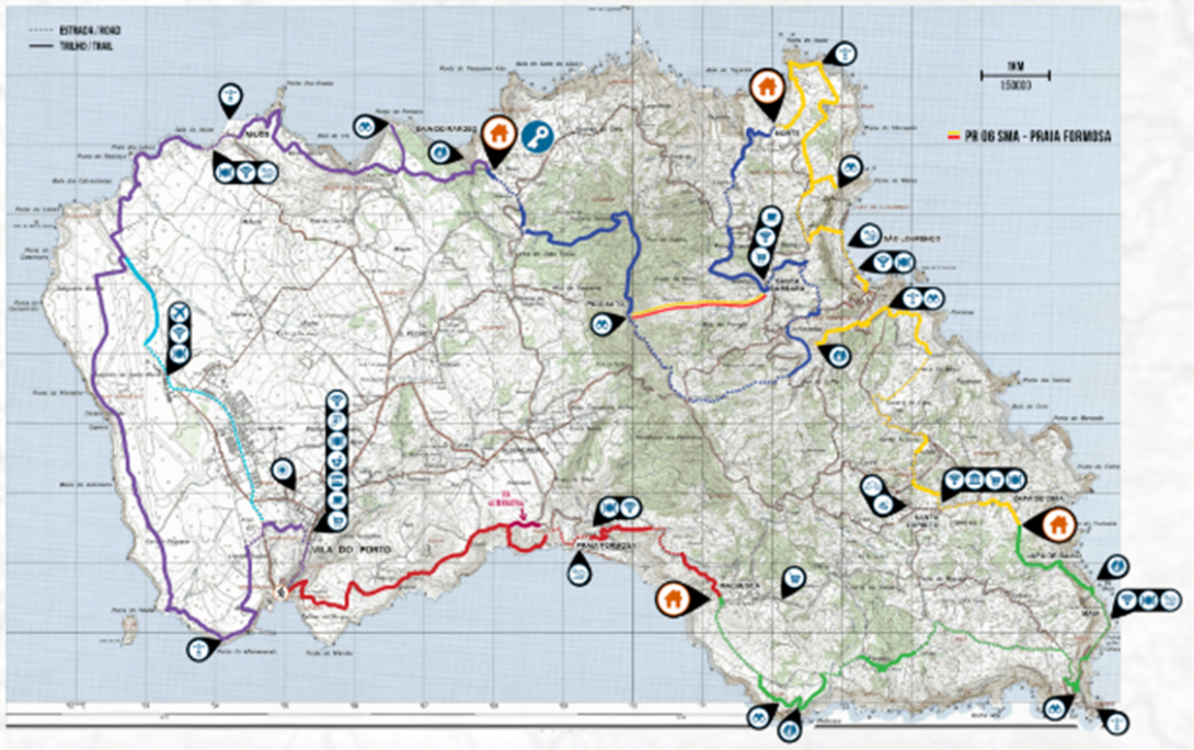
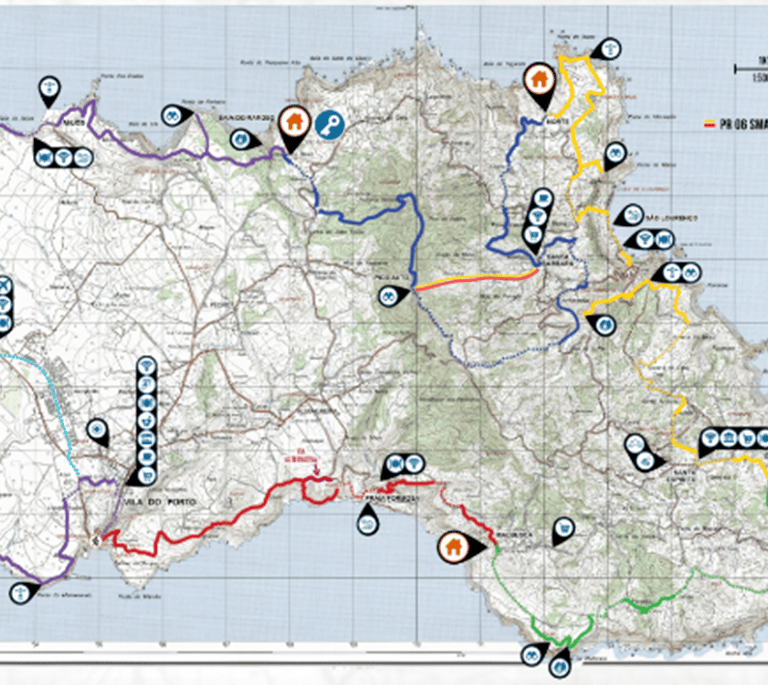
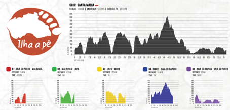
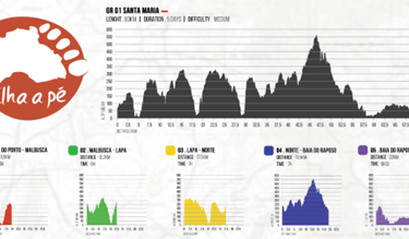
The Grand Rota de Santa Maria (GR1SMA) is a trail that allows a person to hike around Santa Maria Island over 5 stages. The total distance is roughly 50 miles.
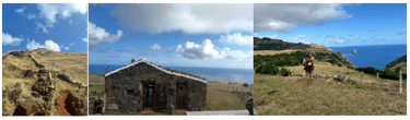
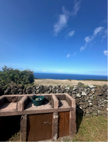
Most people stay in huts along way through the “Ilha a Pe” accommodation service. Translated to “Island on foot”, this service provides hikers with shelter and food along the route. There are four huts strategically placed in stunning, isolated spots along the way. Food is a big part of the Ilha a Pe experience. Expect delicious food to be waiting for you when you arrive at the huts. Dinner is usually a one pot meal that simply needs to be heated up on a stove. Usually a hearty stew, the food I ate at these huts was some of the best food I had in the Azores. The huts are spacious, clean and quiet. They have an outdoor sink for cleaning and a clothesline for hanging wet clothes. Oh, and expect an incredible view of the sunset every night.
In the summer of 2024, I hiked around this beautiful island. It was an experience that I will never forget. Here is my story.
Stage 1: Vila Do Porto to Malbusca Hut
The hike starts in the quaint town of Vila Do Porto. The hilly town is quiet with a small Main Street running through its center. A short walk-through town and down to the ocean brings you to the official start of the hike at Sao Bras Fort. From there the hike heads East along the coast on a grassy trail. The coastal views of the Atlantic dominate the scene.
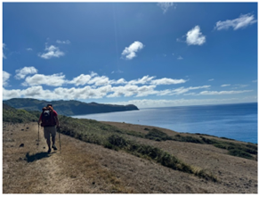
The first few miles of the trail are mostly flat before it starts a slow incline towards the Eastern side of the island. This island is not “built up” by any means. I couldn’t make out a single building or road for as far as I could see. However, I did see windmills. Lots and lots of windmills. They lined the horizon giving the island a mystical feel. It was difficult to judge just how far those windmills were in the distance. I knew this was a small island. I wondered if I would be seeing those windmills for the entire trek. The trail started to gain altitude as the sun continued its slow, methodical rise on the horizon. As the sun rose, so did the temperature. Each hour noticeably more uncomfortable than the last. One interesting fact I learned pretty quickly on this island is that the UV index seemed to be unnaturally high. I checked my phone and the index was at 8. Given that it was only 11 AM, I knew that the sun was going to be a big factor on this hike. I passed a horse that I mistakenly thought was a statue but as I got closer, its tail began to wag. There was no one around. Not a sole. Just a horse standing oddly still in the warm sun.
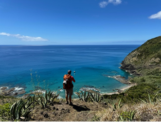
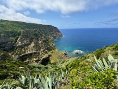
I continued on as the trail reached a plateau. From my vantage point I could see a beach tucked into a cove in the distance. I looked at my map. Perhaps this was Formosa Beach? Formosa Beach was marked on my map, but I didn’t see any people or buildings. I knew Formosa beach was a popular spot for beach goers and offered a beachside café amongst other establishments. The beach I was looking at was just a small sandy alcove tucked into a coastal inlet. I was intrigued so I followed the trail down. I had been told that there were many hidden beaches on this island. This must be one of them. The long descent took a lot out of me. I wasn’t used to a sun with this kind of strength. A quick check of my phone told me that the temperature was close to 80 degrees, but worse than that the heat index was now at 10. I have never seen a heat index that high. Yes, the sun would definitely be a worthy adversary on this trip.
The path led through some trees and then out onto a small beach. A couple of boats were anchored a few hundred yards off the shore. Those boats picked a pristine area for which to relax and take in the scene. I was jealous of the boats until I walked out onto the beach. There was no one there. How could there be no one on this amazing beach? Within 3 minutes I was in the water. As I floated in the water, completely relaxed, I thought about how rare places like this were these days. If this was the US, this place would be a mob scene. Here, it was completely empty. An uninhabited paradise that I had all to myself. I didn’t want to leave. Was this hike going to be like this the entire way around this island? The thought intrigued me. Another 20 minutes slipped by. I still had a long way to go to get to my hut, so I left the ocean, dried off and checked my map.
A trail followed along the beach before heading up and over some rocks. I could see that the trail continued along the rocky shoreline, so I followed it. After a few minutes I could see Praia Formosa in the distance. I saw people for the first time since I started my trek. I also could see the restaurant that was right next to the beach. I started to get hungry. After another 30 minutes of walking I arrived, entered the restaurant and sat at a table.
I ordered some chicken wings that had a BBQ style flavor and an Azorean beer. The flavor of the wings was unique, not like any chicken wing I had ever tasted. I couldn’t make out the spice profile, but I didn’t care. They were delicious. I savored the food, drank the beer (also delicious) and headed out. Once again, I consulted the map and found the trail.
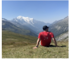
From the beach the trail crosses the main road and heads straight up a hill along a wide path. The path picks up elevation quickly before leveling off and continuing East along a high ridge. From the plateau I could see the coastline for miles. The blue of the ocean was stretched out far and wide reminding me of where I was. The feeling of isolation was odd. I was on an island. A small island at that. From a plane It would look like postal stamp. Inconsequential. Unimportant. Forgettable. For some reason this messed with my mind. Perhaps it was because I was used to hiking through an infinite landscape. The Dolomites were endless. The Swiss Alps were limitless. And the Himalayas… well, they were the Himalayas.
Here, the path was contained. 50 miles of shoreline and that was it. Even more odd, there were no people on these paths. Was it too hot? Sure, there were people at the beach and in the small towns but everywhere else was completely void of people. This was going to take some time to get used to. I passed a group of light brown cows. No, not quite brown. More of a caramel. I had never seen cows this color. Not only was their color odd, but these cows seemed to be on steroids. Was this a unique breed of cow I didn’t know about? Maybe the lack of people allowed the cows to flourish into some kind of super species? Will the cows someday eliminate the people and claim this beautiful island for themselves? I made a mental note to read up on these cows when I had internet access.
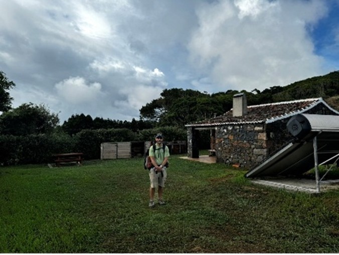
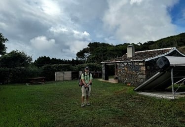
I followed the trail for a few miles before arriving at the first hut; Malbusca.
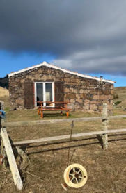
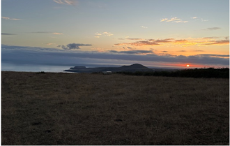
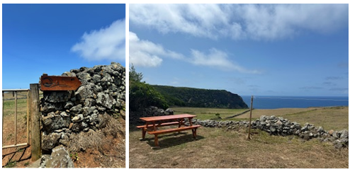
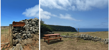
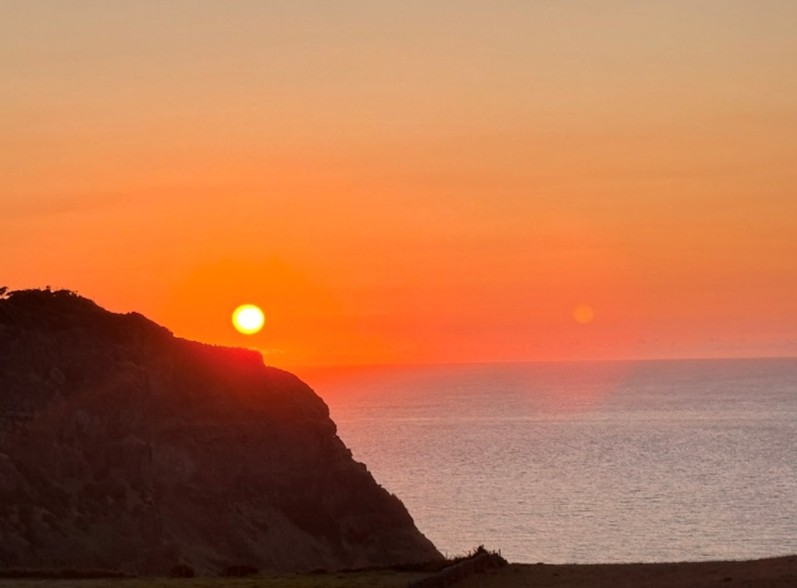
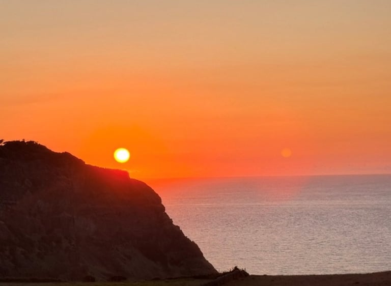
I didn’t know what to expect from the huts, but shortly after arriving at Malbusca I realized that these huts were a perfect representation of this island. Quiet, clean, and beautiful. The backyard of the hut overlooked the ocean. There were very few buildings around and I didn’t see a single person. All I could hear was the rustling of the breeze, nothing else. I stood there in the quiet, staring at the ocean. I tried to take it all in. I tried to stay in the moment knowing that this experience would fly by in an instant. After a few minutes I decided to go into the hut and take a shower. After my shower I heated up my food and headed outside to sit at the picnic table. I savored the delicious food while I watched the sun slowly crawl its way down the blue canvas of a sky before converging with the ocean at the horizons edge. The intersection of sun and water exploded into a Van Gogh right before my eyes.
Day 1 was one of the most peaceful hiking experiences I have ever experienced. The image of the sunset from Malbusca will remain with me for a long time.
Stage 2: Malbusca Hut to Lapa Hut
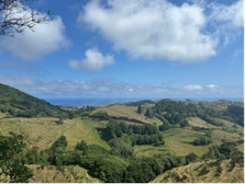
Day 2 was even more remote than day 1. As far as I could tell, this island was mostly comprised of incredible scenic landscape and not much else. Again, if this were the US, every square foot of path I walked would have a multi-million-dollar mansion on it, overlooking the ocean. This place was truly a hidden gem. No houses, no cars, no people. It was as if I went back in time to the days before the industrial revolution. I felt like the luckiest time traveler on earth.
The path continued to follow the shoreline. I had two vantage points to focus on as I walked. Green for a far as I could see on the land. Blue for as far as I could see on the water. That was it. I found myself trying to slow my pace in an attempt to stretch the day out.
Before long, the path bends to the West and heads inland towards the center of the island. I followed along intrigued to see what was next. I was not ready for what I saw. Up ahead there was some kind of giant “wall”. I wasn't quite sure what to make of this geological anomaly. What in the world was it? It looked like some kind of rock formation right out of a Jurasik Park movie. I don't think I would have been surprised to see a tetradactyl nest or one of those tiny dinosaurs that hop around and spit poison at you. I continued down the path eager to get closer.

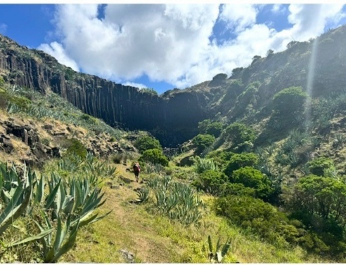
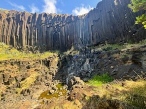
The concave wall blocked my way. What was this thing? It embraced the landscape as if protecting it, hugging it tightly and not letting go. Giant columns of basalt, the color of dark browns and light blacks stretched up to the sky. Waterfalls trickled down it and into a pool at the rocky bottom. The trail approaches this incredible scene from the bottom. I stared at it in awe. The closer I got, the larger it became. Was it protecting me from something? It reminded me of the wall from Game of Thrones. Would trolls and white walkers be waiting for me on the other side? I had never seen anything like this in my life. I would later learn that the locals refer to it as “gigantica.” I could not come up with a more fitting name. Science says that it was created by some volcanic eruption a very long time ago. How it resulted in what I saw before me, I could never explain. Somethings can’t be explained. This was Mother nature’s handy work. That’s all the explanation I needed. This was more magic than science and Mother nature’s magic is certainly something to behold. Once again, I was thankful to be here. To encounter nature like this was a humbling experience.
The trail climbs up and over the side of gigantica. I climbed up eager to see what was on the other side. There was nothing. No trolls. No white walkers. Just a boundless grassy plain that extended out across the landscape for miles.
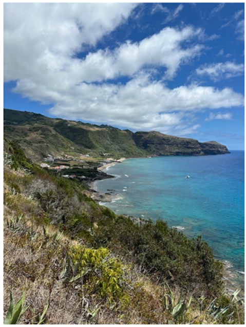
The next section of hiking is the approach to the small coastal village of Maia. To get to Maia you have to tackle a section of road that winds its way down to the village along the coastline.
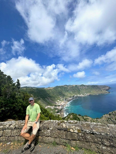
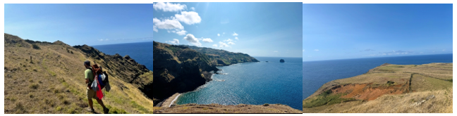
I stopped to take a picture at a viewing area overlooking Maia when a woman who had parked her car there approached me. She looked to be in her early 60s. She spoke Portuguese. Before I could communicate to her that I didn’t speak Portuguese she spoke in English. “Are you hiking around the island?”. I told her yes. Her English was perfect. She then told me that she was American and she was originally from California. Her and her husband moved here for retirement. This intrigued me. We chatted for a while. I had questions about why this place was so uninhabited. She smiled and put a finger over her mouth. “Don’t tell anyone.” She was clearly passionate about the island, and she told me I had chosen a great place to hike. She asked me about my itinerary, and I told her I was headed to Maia. "Good luck on the hike out," she said. I gave her a quizzical look. She said that the hike out of Maia was basically a giant staircase from the town and up over the hill side. You can see the town in the above picture. Draw a line up and over those mountains and that was the hike out. It was something to look forward to.
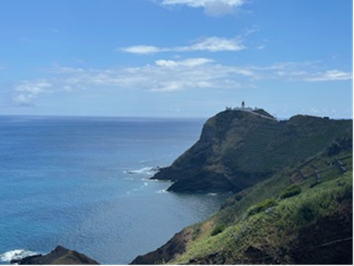
This was also the sight of a famous lighthouse photo (above pic). If you google Santa Maria, you will likely get a plethora of pictures of a light house sitting on a peninsula overlooking the ocean. Its quite beautiful. I tried to take pictures of it, but I didn’t quite capture its beauty. I said my goodbyes and spent the next hour hiking down the steep winding road to the village of Maia. When I got there, I noticed a bunch of people swimming and bathing in a pool, but this was not your typical pool.
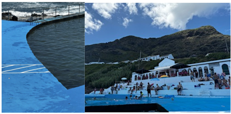
This pool was a “natural” pool. It was an enclosed circle like the pools I know, but the ocean crashed into it and its waves poured into it. It was basically a place where people could bring their families and get the “pool experience”, but with the ocean. There were plenty of places to sit. There was a restaurant with tables overlooking the pool. There were also bathrooms, changing rooms and showers. It was amazing and it was free. Yup, you heard me. Free. Another concept that would be unheard of in the States. I spent some time here cooling off in the pool. I was surprised to see fish in the pool, but after looking around, it wasn’t that surprising. This "pool" was just an extension of the ocean. It was a fascinating concept. So simple and so effective. I spent about an hour at this pool swimming, eating and relaxing before continuing my hike.
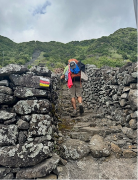
The next section was indeed a large staircase through manmade vineyards sectioned off by rock walls. I thoroughly enjoyed weaving my way up these stairs and through these vineyards. It got steeper and steeper until you reach the top and arrive at the Aveiro waterfall.
From there, the trail takes you inland and along a road. I could sense that I was getting close to the hut. Sure enough, after about 5 minutes or so I could make out the hut, hidden in the trees. I made it to Lapa.
The Lapa Hut was similar to the Malbusca hut, but this location was tucked into a forest area amongst trees. This is the only hut that didn’t have spectacular unobstructed views of the ocean. It was still an amazing spot to rest, relax, and eat a nice meal. I went to sleep eager to see what stage 3 had in store for me.
Stage 3- Lapa Hut to Norte Hut
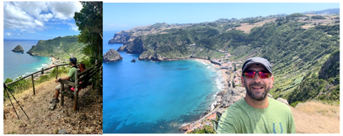
Stage 3 was my favorite stage of the entire hike. Much of the day’s efforts involved getting to Sao Lourenzo, another coastal town carved into the cliffs overlooking the Atlantic. I was excited to check out Sao Lourenzo as I had heard much about its beauty. The hike to Sao Lourenzo went by in what seemed like minutes. When I arrived at the village, I was amazed to see another natural pool. This village was like Maia, but seemed to be a bit larger and more built up.
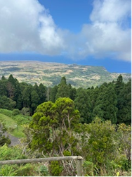
I stopped to eat lunch and take a break before tackling another uphill staircase-like climb through more ancient vineyards. This one wasn’t as remote as the climb out of Maia and it culminated at the site of a real estate construction project. Someone was building a house here that overlooked the village and the ocean. It was the first construction I seen so I couldn’t possibly complain, but it did take away from the hiking experience. Perhaps it was because I wasn’t used to it. From there I followed a street downhill before entering my favorite section of the entire hike. The trek to the Norte hut from here was pure magic.
It was one of the most beautiful sections of hiking I have ever encountered. I could walk this trail everyday for the rest of my life and be a very happy person. The grasslands stretch out into eternity. A faded path was only noticeable if you really look closely. Small 6 inch trail markers popped out of the ground at irregular intervals. They helped to guide the way, but the truth was you could walk anywhere. It was all fair game. The wind provided a breeze that took the edge off the heat from the sun. The views were exceptional. I sat down and took it all in. If I died here, I would die in peace. I decided then and there that I will be taking my daughter here one day so she can experience this place. I kept walking hoping the section would never end.
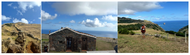
The trail then climbs up in to the hills and toward a smattering of buildings. Here I found my hut; Norte.
The location of the hut was ridiculous. I have no other words to describe it. I thought about what this hut would sell for in California or some other coastal state. Tens of millions just for the view itself. This was the peak of the hike for me. I was hungry so I showered and settled down to eat my stew at the picnic table. I took a mental picture of the scene trying to capture all that I saw, felt and smelled. I hoped to imprint it in my mind so that I could refer back on it and recapture the feeling. This was a truly special place. Another night, another sunset. I went to bed with a feeling of contentment I have only found when I am hiking in the mountains. I wasn’t in the mountains, but this place was every bit as magical.
Stage 4 Norte Hut to Reposa Hut
Stage 4 sets a Southern course inland to the mountainous area of the island. Today I would summit the highest mountain on Santa Maria. It went by the name Pico Alto.
The hike up to Pico Alto wasn’t too difficult. Instead of a straight climb to the top, the trail meandered between steep ascents and flat traverses. As you can imagine, this section was chalk full of amazing views from the higher vantage points. It was a bit cloudy on this day, so my pictures didn’t turn out as good as I wanted them to, but it was still beautifully scenic.
The peak itself was a fenced in summit with a radio tower in the middle. This took away from the experience for me. The summit was also accessible by a road so there were buses letting people off so they could check out the peak. The sight of people was jarring. It sounds ridiculous, but after so long without seeing many people at all, the sight of all these tourists (there were probably only 9 or 10) somehow diminished the Pico Alto experience for me. It’s absurd to feel that way. I know that. It’s the thoughts of a spoiled and entitled hiker, but that’s the island’s fault. It had conditioned me to feel this way. It had already shown me it’s true self. This wasn’t it. The summit did have a 360-degree view of the island which was pretty cool to behold. I could see the outline of the entire island. Once again, it gave me perspective as to where I was and what I was experiencing.
I didn’t linger long as I was eager to get back to the isolation and quiet of the trail I had grown I love. The hike down from the summit wasn’t overly exciting. The trail passed through more grassy fields before giving way to some road sections. The final approach to the Reposa hut was relatively uneventful. I remember thinking that the Norte Hut was the pinnacle of what a hut could be. That Reposa couldn’t possibly approach what Norte had been. I was wrong. If Norte was an A, the Reposa was an A++.
I couldn’t think of a better way to spend the last night of this trek than at this amazing hut. The views from the backyard took my breath away. Furthermore, the map showed a path down to what looked like a hidden beach. I was intrigued. After resting for a bit, I packed up a small bag and headed down the path.

I could make out a cove on the shoreline in the distance, but the path to get there was straight down for what looked like a mile. This was going to be fun. The trail switched back at least three dozen times along the way. After about 30 min I arrived at a small rocky beach. The beach was empty. I spent over an hour at this beach taking pictures, swimming and taking in the scene. This was the icing on the cake. My own private hidden beach on my own private island. Will I ever experience something like this again? Unfortunately, it was unlikely. To this point on my trek (all 4 days) I had seen about 100 people. Conversely, I saw about 200 cows. That was an improbable ratio, but I guess that’s to be expected in such an improbable place.
I walked back up to the hut for dinner. A melancholy started to settle in as I knew the dream was about to end. I sat outside at the picnic table and watched the sun set for my final night in Santa Maria.
Stage 5 Reposa Hut to Vilo Do Porto
The final stage is quite different than the previous four. Known as the red desert, this stage is mostly flat and passes through a red clay landscape. This was not my favorite stage, and it could certainly be skipped if needed. It is unique, but after a couple of miles, the novelty wears off. It’s just a bit boring and it culminates at the airport, a sober reminder that my time on this island was coming to an end. You still get beautiful views of coastal Santa Maria, but the section didn’t have the heart and soul that the previous sections had. I spent my last day reminiscing about the island and my hike. I still couldn’t figure out why this island wasn’t a tourist trap like some other islands in Europe. It wasn’t built up and I guess that may turn some people off, but to me that is what made it so special. It was like taking a trip to the past to a simpler time. No obnoxious built-up homes. No traffic. No people in a constant rush. The allure was in its simplicity and its serenity. Oh, and of course, its staggering beauty. It was a recipe worth remembering. All the ingredients carefully chosen and mixed together to make the ultimate creation, Paradise.
The hike ended where it started in the quaint village of Villo do Porto. I had come full circle (literally and figuratively).I experienced many feelings after this hike, but the most lingering feeling was that of appreciation. Appreciation of the opportunity to experience this place. Appreciation that places like this still exists. Appreciation of the way people on this island lived. Appreciation of the simplicity of life here. The hike was finished, but my appreciation of places like Santa Maria only grew. This wasn’t just another hike. For me, this was an enlightenment. This was proof that there are still places out there that can truly surprise you. There are places that can tap into your soul in ways you didn’t think possible and leave their mark on you. Santa Maria holds a special place in my heart, and I will never forget the experience I had there on my five-day trek around the island.
-MikeHikeTheAlps, August 2024

Contact
Questions or stories? Reach out anytime.
mikehikesthedolomites@gmail.com
© 2025. All rights reserved.
-MikeHikesTheAlps

