
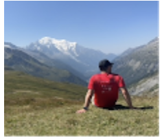
NH's Presidential Traverse in 1 Day
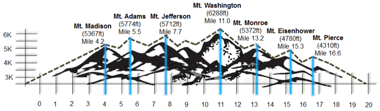
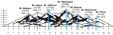
The Presidential Traverse is one of NH's most challenging and scenic hikes. At close to 20 miles and 9,000 FT in elevation gain, it will test even the most seasoned hikers. While most people complete it in 2-3 days, it is possible to complete it in 1 day. I try to complete it every year. This time I took my brother (and some friends). Here is my story.
QUICK HITS
MikeHikesTheAlps
7/19/202516 min read
Introduction:
The Presidential Traverse is one of New Hampshires most beautiful and challenging hikes. It covers roughly 20 miles along a continuous ridge that passes through 7 of NH's highest mountain peaks, all of which are named after US Presidents. There is even an option to tackle a 8th peak, Mount Jackson (this option adds mileage and elevation). Most people take 2 or 3 days to hike the traverse. They will either camp at one of the campsites along the way or stay at one of the mountain huts. If you are the adventurous type, it can be completed in 1 day. It takes roughly 9-12 hours to complete. Keep in mind that this is just a range. There are a number of variables that can change the amount of time it takes to complete this hike.
With about 9,000 feet in elevation gain, you will want to make sure you train before attempting this challenge. While the distance and elevation gain are enough to scare most people off, the biggest challenge in my opinion is the terrain. I would describe the trail as extremely "unforgiving," especially the first half. Expect your feet to take a consistent beating for the first 11 miles as the path is mostly comprised of jagged sharp rocks that require a lot of focus and precision. You can forget about hiking fast until you get to Mount Washington. After that, you will likely be too tired to hike fast anyway.
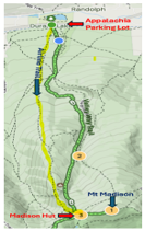
The trek starts at the AMC Highland Center at Crawford Notch in NH and ends at the Appalachia Trailhead in Randolph, NH. As this is a point-to-point hike, you will need to find a way to get back to your car once you reach the AMC Highland Center. It is roughly a 45-minute drive. I usually park a car at the AMC Highland Center prior to driving to the Appalachia Trailhead to start the hike.
I strongly recommend you use a GPS app to help guide you on your hike. I use All Trails and It has saved me a few times. Weather is always unpredictable. It can be sunny with low wind and high visibility one second, and foggy and windy the next. When visibility is bad, it can be challenging to navigate the path. This is where GPS becomes helpful.
The nice thing about this trek is that you don’t need to worry (for the most part) about water and food. This means you can pack light! You will pass the Madison Hut at about the 4-mile mark. From the Madison hut it is roughly 6 miles to Mount Washington (Indoor Cafe). From Mount Washington it’s about 1.5 miles to Lake of the Clouds hut. And from LOC it’s about 8 miles to the AMC Highland Center Parking lot. All of these places have free water fill up and food for purchase. You just need to make sure you have enough food and water to get you to the next fill-up location. Just a quick note about packing. While packing light is critical to your success, you still need to plan for bad weather. Make sure to throw a winter hat and some gloves in your pack. You just never know with Mount Washington.
In July of 2025 I decided to take my brother (and 2 friends) on his first Presidential Ridge hike. Here is our Story:
Madison
From the AMC parking lot, there are two trail options that will get you to the Madison Hut, which is the first milestone of this hike. The “Official” Presidential Traverse route has you take the Valley Way Trail. I prefer the Airline trail. It runs (mostly) parallel to the Valley Way, but it is, in my opinion, a much more interesting and scenic trail. The Airline trail is longer and harder, but it’s worth it. Trust me.

We started our hike around 5 AM. It was mid-July and the weather was looking good. The four of us headed up the Airline Trail as daylight broke. We eased into a comfortable walking rhythm as the trail started to gain altitude. My brother, who was not a seasoned hiker by any means, was determined to complete this trek. Everyone has their strengths and weaknesses. Determination was his strength. Preparation and common sense were his weaknesses. Case and point, he carried a plastic bag filled with pealed hard boiled eggs in his left hand. I would classify this decision as unconventional, but that’s being nice. Disgusting and repulsive are more fitting adjectives. I mentioned this to him. In response he made an offhand comment dismissing my suggestion that hardboiled eggs were not a good hiking food. He popped an egg in his mouth as he hiked. I wanted to vomit at the sight of it.
The trail cut its way through the dense forest on a slow and steady incline. Like most hikes that involve summing a mountain peak, the first section is typically uneventful. If you want the cake, you need to eat the meat and vegetables first. I watched as my brother slipped and fell to the ground. His bag of eggs bounced off the trail and into the woods collecting dirt and twigs along the way before settling on a patch of leaves. He got up, dusted himself off and went over to pick up the bag of eggs. I watched in awe (or horror) as he inspected the bag closely. He wiped off the dirt, clutched the Ziplock bag in his hand and kept walking.
Over the years I have learned through trial and error what food(s) to bring with me on a hike and more importantly, what foods not to bring on a hike. While every hiker has their own personal “go to” hiking food, there are some general rules to follow. 1. Weight is important. Lighter is better. Always. 2. Don’t bring food that can spoil. It is summer. You will sweat. The sun will shine. Based on these simple tried and true rules, hard-boiled eggs don’t pass the test. The thought of the sun beating down on the dirty and sweaty eggs made me never want to eat an omelet again. I tried not to look at the bag of eggs as I hiked, but it was like an accident on the highway, I couldn’t not look. In a battle of intrigue versus disgust, intrigue won out. I became obsessed with these eggs. This is how I passed the time on this section.
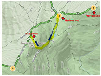
As I mentioned before the first milestone of the hike is getting to the Madison Hut. The hut sits comfortably in the shadow of Mount Madison, the first of the 7 peaks on the Presidential Travers route.

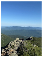
After about 3 miles or so on the Airline Trail, you exit the trees and enter the alpine. Exiting the trees is always an euphoric experience. The crisp mountain air slaps you in the face waking up your senses. The confines of the trees just moments before are replaced by a cathedral of open air as far as you can see. In the early morning, the ridge lights up with the rising sun creating a soft glow that illuminates trail as if it’s inviting you to continue down the path. The backdrop of mountains, canyons and valleys surround you in array of color. A thousand shades of green, grey and blue. It’s a sensory overload. It’s inspiring. It’s magical. This is why I love the mountains. It’s also why I chose to take the Airline Trail instead of the Valley Way. No such ridge exists on the Valley Way. This was a bonus level in an already epic game. For me, this is where the hike truly begins. After about a ½ mile long journey along the ridge the trail dips down before arriving at the Madison Hut.
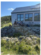
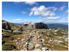
People congregated outside the hut chatting with each other, eating snacks and drinking water. The hut serves many purposes. Food, shelter, water (via a water spicket outside), rest, bathrooms, and camaraderie. I always recommend leaving your pack at the hut before summiting Mount Madison because after summiting the peak, you have to go back to the hut before tackling Mount Adams. We left our packs and headed up the Madison trail. At this point everyone was still fresh, but that was about to change. The Madison summit hike is not overly challenging, but compared to the Airline Trail, it’s an adjustment. Large boulders litter the path making for an enjoyable scramble up the mountain. Theres plenty of space to choose your own path, which is good because it was crowded, even this early in the morning.

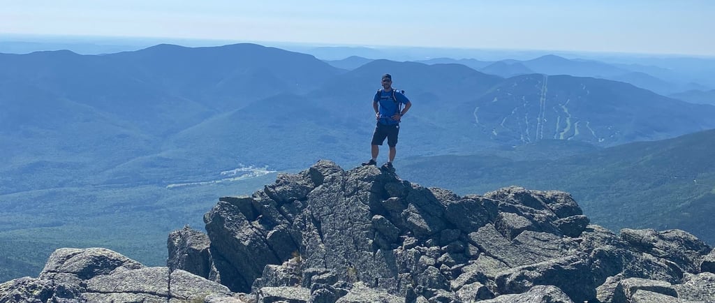
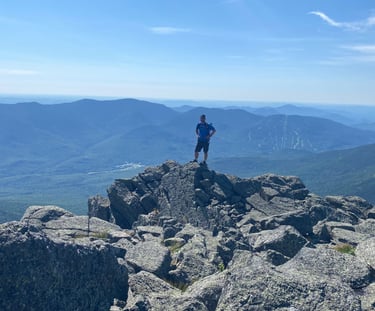
After about 40 minutes, I stood atop the 1st of 7 peaks. I took in the scenery. You could see the next few peaks on our route. You could see Mount Washington with its road weaving up the side of the mountain. I love Mount Madison. It’s hard to explain, but when I am on its peak, I feel a sense of peace. I’m not sure why, but every time I’ve been up there, I feel it. It’s one of those unexplainable things that only seem to happen in the mountains. After a few pictures we headed back down towards the Madison Hut.
Adams:
When we got back to the hut, we had a snack, used the restrooms, refilled our water, packed our stuff and headed off. From the Madison Hut, you have two path choices to get to Mount Adams. One is hard, one is easy. We took the hard one.
We headed down the Star Lake Trail which traverses along the bottom of the backside of Mount Adams. At least I think it’s the backside. Either way, it’s the hard side. I have done the Presidential Traverse 5 times and I can safely say that the hike up the backside of Adams is the most challenging section of the Presidential Traverse. It’s technical. It’s in the sun and it’s relentless. This is the part of the hike where the group started to split up. It’s important to allow people to hike at their own pace. While we are hiking as a group, hiking is a personal experience. I try not to dictate someone’s else’s pace. As they say in the hiking community, hike your hike. Two of us set a pretty aggressive pace while the other two took their time. The hike up the backside of Adams is a steep and technical scramble all the way to the top. Temperature control is important because if the sun is out, it will beat down on you the whole way up.
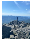
We all met at the top where we celebrated conquering the 2nd of 7 peaks. We had a long way to go so we headed down the jagged rock path carefully plotting our route towards our next peak, Mount Jefferson.
Jefferson:
The hike from Adams to Jefferson is a mostly “flat” traverse, at least by Pressy Ridge standards. It’s easy to take this section for granted, but because the path is filled with jagged rocks, it’s important not to lose focus. One misstep can lead to a turned ankle or a nasty fall. As we hiked, I asked my brother about the eggs. His face went pale. Perhaps the experience of hiking up Adams in the sun with the bag of eggs in his hand was not as pleasant as he had hoped. I can only imagine the smell. He pulled out another bag, this time of cut watermelon. Cut fruit with a high-water content sounds a bit “messy” for a hike.. I won’t lie to you and say that a nice piece of cool juicy watermelon doesn’t sound delicious. It does, but there is a reason people tend to bring dried fruit on hikes. The Ziplock bag had filled ¼ of the way up with watermelon juice, bathing the warm watermelon pieces like Russian men bathe in a Turkish bath. I imagine that since the bag of watermelon was in his sweaty pocket it didn’t quite hit the spot as a cool hydrating snack, like he hoped. Who’s to say? To this day he swears by his watermelon decision.
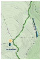

Prior to the final ascent of Mount Jefferson, there is an option to take a path that bypasses the summit and connects with the path on the other side. It’s called the Gulfside Trail and it’s a good option if you are hiking with anyone who is tired or struggling. There is no shame in skipping a peak. All four of us decided to tackle the peak. Again, two of us took the lead and two fell behind. At the top of Jefferson, we took a picture and had a snack before descending. Three down, four to go.
The section between Jefferson and Washington is what I like to call a long, never-ending slog. To this point you feel great about completing the hike. You feel like you’re making great time, but the reality is that the true test is about to begin. This section is a bit of time warp. You know that Mount Washington is up ahead and sometimes you can even see it, but getting there requires patience.

After a couple of miles you will be faced with another decision. You can tackle the Mount Clay Loop trail, or you can stay on the Gulfside Trail. The Mount Clay Loop Trail adds significantly more elevation gain and allows you to summit Mount Clay, which is a mountain but isn’t a mountain. What? Well, apparently, it’s not recognized as a 4K peak in NH because it is technically a “sub peak” of Mount Washington. Two of us decided to tackle Clay and two of us took the way around. We met back up when the trails converged and continued on route toward Washington. The trail starts to get steeper here and now close to 10 miles in, the efforts of the day start to compile. My brother and our friend Steph started to struggle here. Me and our friend Trish pushed ahead. At this point you can hear and perhaps even see the Cog Railway. This time of year, the train takes folks up (and down) to the Mount Washington peak constantly throughout the day. As you approach the final ascent up to Washington, you actually cross over the cog railway track.
Trish and I arrived at Mount Washington peak and headed inside to the café. 25 minutes later Mark and Steph joined us. Here we ate lunch, and used the bathroom. I also changed my shirt. Donning a new shirt has magical powers. It refreshes and invigorates me. It’s essentially like taking a shower. I wouldn’t call it a mountain hack, but I strongly recommend it. At lunch we discussed the second half of the trek. Steph was clearly hurting and we offered her the solution of taking the train down. She took the option as she was dealing with some serious pain. My brother, who also seemed to be hurting, decided to continue on.
Munroe
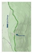
The hike from Mount Washington down to the Lake of Clouds huts is my favorite section of the Traverse and one of my favorite places on Earth. The Lake of Clouds hut sits on a small mountain lake nestled between Mount Washington and Mount Munroe. On a clear day the scene is pure magic.
The descent down from Washington to the LOC Hut is essentially a giant staircase. The rocks are generally smooth, and the difficulty of the descent is relatively low. For these reasons, I tend to hike this section fast. It’s a good way to make up time. When we got to the hut, we took a 10-minute break to refill water, eat a snack and use the restroom. From the hut, a switchback trail leads up and over Mount Munroe. There is also an option to hike around Munroe instead of over it. The trail meets up on the other side. I asked my brother if he wanted to bypass the peak and he said no. Again, he was determined to complete this hike. We headed up and over Munroe. It took us longer than it should have and we were already behind pace for the day. The hike to Washington had taken its toll. There was nothing that could be done about it, so we headed on in a single file trying to keep each other in viewing distance.
Eisenhower
The hike to Eisenhower from Monroe is very enjoyable. Once you pass “Little Monroe” (another sub peak) on the way down from Munroe, the landscape starts to change. The trail begins to weave through narrow paths enclosed in trees followed by baren flat rock slabs before dipping back into the trees again. After a couple of miles on the Crawford Path, you will be given the option to take the Franklin Trail, which is short trail that passes through Mount Franklin. I recommend grabbing the Franklin peak while you are here. While it’s a bit of ascent, it’s nothing too difficult and is worth the views alone. Mount Franklin is another mountain that isn’t a mountain as it isn’t considered an official peak. Good thing because Franklin wasn’t a president and this is the Presidential Ridge, after all. After Franklin, we made our way towards Eisenhower. This section is not overly difficult, but at this point in the day, fatigue starts to set in. This was particularly true with my brother. He started to fall behind regularly. When I saw him, he seemed to be walking gingerly. It was remarkable he had made it this far, but that didn’t change the fact that I was starting to worry. Daylight was running out and we still had a long way to go. Once on top of Eisenhower, I checked in with my him. He was clearly “off”, but he still had determination in his eyes. We continued on. There was no other choice really. I had brought a headlamp just in case and at this point I was starting to think we would need it.
Pierce:
The hike to Mount Pierce is kind of meh. It’s a long traverse through more trees and more open flat rock slab sections. This part of the trek is at a lower elevation, and it is noticeable by the change in terrain. The tree lined trail sections are longer and the trail meanders through some boggy sections with wooden makeshift “bridges” to keep you dry. While the Eisenhower Peak is above the tree line, Mount Pierce is not. Mount Pierce is, therefore, the least scenic part of the entire trek. With the sun sinking fast, our pace slowed. My brother was in a fog. He was still moving forward, but his movements were sluggish. His eyes had dulled. He was in survival mode. One step in front of the other. That’s all he could do. For the next hour or so, Trish and I would push ahead, wait, then push ahead again. A couple of times we waited for such a long time, we started to worry that he had gotten lost. Before long he’d pop up on the trail. He was moving slowly, but he was moving. Mount Pierce’s official summit was on a slab of rocks in a clearing surrounded by high trees. It is marked with a metal plate in the ground. There were no views. At this point, it didn’t matter. We were here to summit and officially complete the last peak of the hike. Trish and I got to the summit and waited. Then we waited some more. As we waited, we wondered if my brother had taken a wrong turn. I didn’t see how because we stopped at the last intersection to make sure, he got on the right trail. There was no way to go but towards us, at least that’s what we thought. Once he arrived, we would back track to the last intersection and take the Crawford Path about 3 miles back down to the car. We were losing daylight quickly, but the Crawford path was a relatively easy path down. I knew we would make it if we could just find my brother.
It is possible to continue past the Peak of Mount Pierce and head towards the Mizpah Spring Hut. It was probably another hour (maybe less) to the hut. From the hut you could tackle Mount Jackson. The trail from Mount Jackson down to the car is considerably harder than the Crawford Path. I ruled out this option immediately. Next year we will shoot for that. We were still waiting for my brother Mark. Where was he? I tried texting his phone. Nothing. Another 10 minutes went by before we saw him meandering up the path. He didn’t look right. I asked him if he was ok. His response was more of a grunt than actual words. Clearly, he was hurting. It didn’t matter because he made it! We took a break and tried to assess the situation. He started to come around, and he began to tell us that as he was hiking up to Mount Pierce he stopped, looked around and froze. Apparently, he couldn’t remember if he was going up or down. He was torn on which way to go. He sat there and contemplated. Should I go up or should I go down? Thankfully he decided to go up. In retrospect, we probably shouldn’t have left him. All is well that ends well, so we started to head down. When we got to the Crawford Path intersection, we headed down towards AMC Center where the end of the hike and our car were waiting. After 10 minutes my brother was back to being himself. His eyes cleared up and his body language changed. Was it the LMT he just drank? Or the snack he just had? Did he eat one of his sweaty eggs or some of his warm watermelon? I don’t know, but the transformation was significant.
It was getting dark and we still had to pick up our friend who had taken the train down. We started to jog down the path. Yes, you heard me. Jog! My brother was a different person. He began to pick up the pace and we essentially ran down the path. We did this for two miles. When we got the end we congratulated each other and celebrated with a beer from the cooler in my car. My brother couldn’t believe his transformation. He felt like a million dollars. This has happened to me before. I don’t know what it’s called. A second wind is too simplistic of an answer. Was it adrenaline? Was it mountain magic? There has to be some scientific explanation for it, but I don’t know what it is. I chose to believe it’s something more spiritual in nature. As I like to say, Alpine is a drug. Maybe its powers include rejuvenation. Either way it was a satisfying ending to a satisfying day and I was thankful to be a part of it.
The Presidential Travers is true test of endurance and mental toughness. It took us 13 hours and 48 minutes to complete the hike. Total distance was 20.76 miles. Our total ascent was 8,600 feet. Regardless of the statistics, completing the traverse is a big accomplishment. I am proud of my brother for his determination and grit. I hope in the future he learns to pack better food. More importantly, I hope he can figure out the difference between up and down.
Next we tackle the 30 mile Pemi Loop Trail in NH in the Summer of 2026. Till then.
-MikeHikes July, 2025

Contact
Questions or stories? Reach out anytime.
mikehikesthedolomites@gmail.com
© 2025. All rights reserved.
-MikeHikesTheAlps

